
Unwind in Nature: Your Guide to Easy Hikes Near Canmore
Canmore, Alberta is located in the Canadian Rockies and is a gem that should be explored by outdoor lovers. I live an hour away from Canmore and I am sharing with you the 7 best easy hikes near Canmore.
This area is known for its stunning landscapes and it is a haven for hikers of all ages and abilities. These hikes are doable for people of all levels, and great to explore anytime of the year, even if you want to try hiking in the winter, which is my favorite time to hike.
Disclaimer: This post may include affiliate links. If you click one of them, I may receive a small commission at no extra cost to you.
Easy hikes are the perfect way to immerse yourself in your surroundings without the strain of a strenuous trek. These hikes are great for all ages including those who want to learn to hike, are all dog friendly, offer beauty and exercise without the challenge of steep climbs and are all within 30 minutes of the town of Canmore. My dog Lucy and I love exploring these trails when we take a day trip to Canmore and the mountains.
How Do You Get To Canmore?
Canmore is located approximately an hour west of Calgary, which is the closest major city. Head west on the Trans Canada Highway (Highway 1) until you see the signs for the town. Enjoy the beautiful scenery on the drive as you enter into the Canadian Rockies.
If you are spending a day in Banff, you drive right past Canmore, so you could do any of these hikes, as most of them are within 30 minutes of the town.
Do you have to pay to hike in Canmore?
All of the hikes below require a purchase of a Kananaskis Conservation Pass which is $15 per day or $90 for an annual pass. If you plan to spend a weekend, then you would need to have a pass for 2 days ($30.00). I have some great recommendations on places to stay in Canmore for a weekend visit.
The Policeman’s Creek Boardwalk Trail is the only trail that is actually within the town. If you plan to only do this hike – which is more of an easy walk – then you do not need to purchase a pass.
Top 7 Easy Hikes Near Canmore
Grassi Lakes Trail
Distance: 4 kms (2.5 miles) | Difficulty: Easy – Moderate | Dog Friendly: Yes, on leash |
| Loop Route | Elevation: 158 metres (518 feet) | Washrooms: Yes |
This trail starts at the parking lot and eventually splits into two. The path on the right is easier and is called Upper Grassi Lakes Trail. It goes through the forest on a wide path with terrain that is really a great easy hike for beginners and families. The path on the left is called the Grassi Lakes Interpretive Trail which is considered to be harder. As it goes uphill through the trees, it gets steeper. You will see a little waterfall as you near the top and a nice view of the town of Canmore.
Both trails end at the Grassi Lakes, so you can walk either trail in a loop. You can explore around the lakes and watch the rock climbers surrounding the lakes. The blue and green hues of the water are a spectacular sight to see. Some people ask if Grassi Lakes Trail is easy? I would say yes it is but if you tackle it in the winter, there’s a bit of an added challenge with the snow and ice. Ensure you wear crampons if doing this trail in the winter.
Note: In the winter the more difficult trail is usually closed due to being icy from the water on the path.

Grotto Canyon Trail + Add On
| Distance: 4.4 kms (2.7 miles) | Difficulty: Easy | Dog Friendly: Yes, on leash |
| Out & Back | Elevation: 115 metres (377 feet) | Washrooms: Yes |
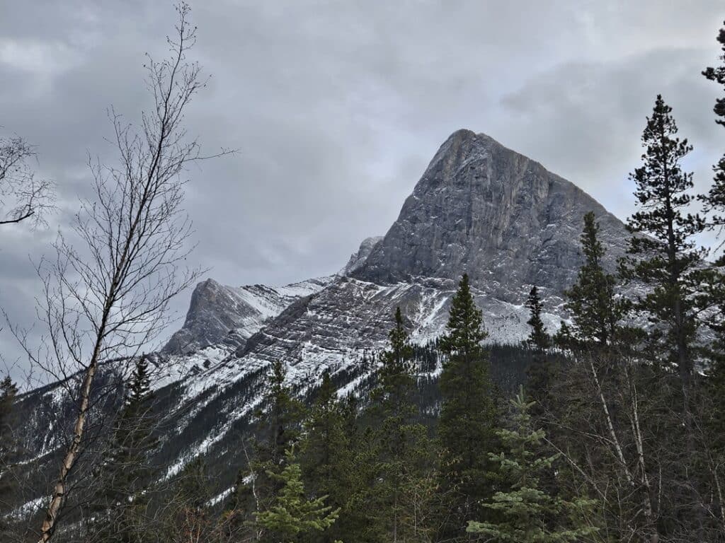
What is the most popular hike in Canmore? That would be Grotto Canyon! Located less than 15 minutes east of Canmore, it is an easy and popular hike that takes you into a stunning gorge at the base of Grotto Mountain. Accessible all year-round, the trailhead is located off Highway 1A and gets very busy, especially on the weekends, so plan to visit early in the day.
The initial part of the trail stretches under power lines and a factory and isn’t that exciting, but within 15 minutes, you will reach the creek bed and enter the canyon, offering scenic views of Mount Lougheed. Sturdy boots are recommended for the rocky terrain. As you follow the trail, you will encounter impressive canyon walls, popular amongst rock climbers.
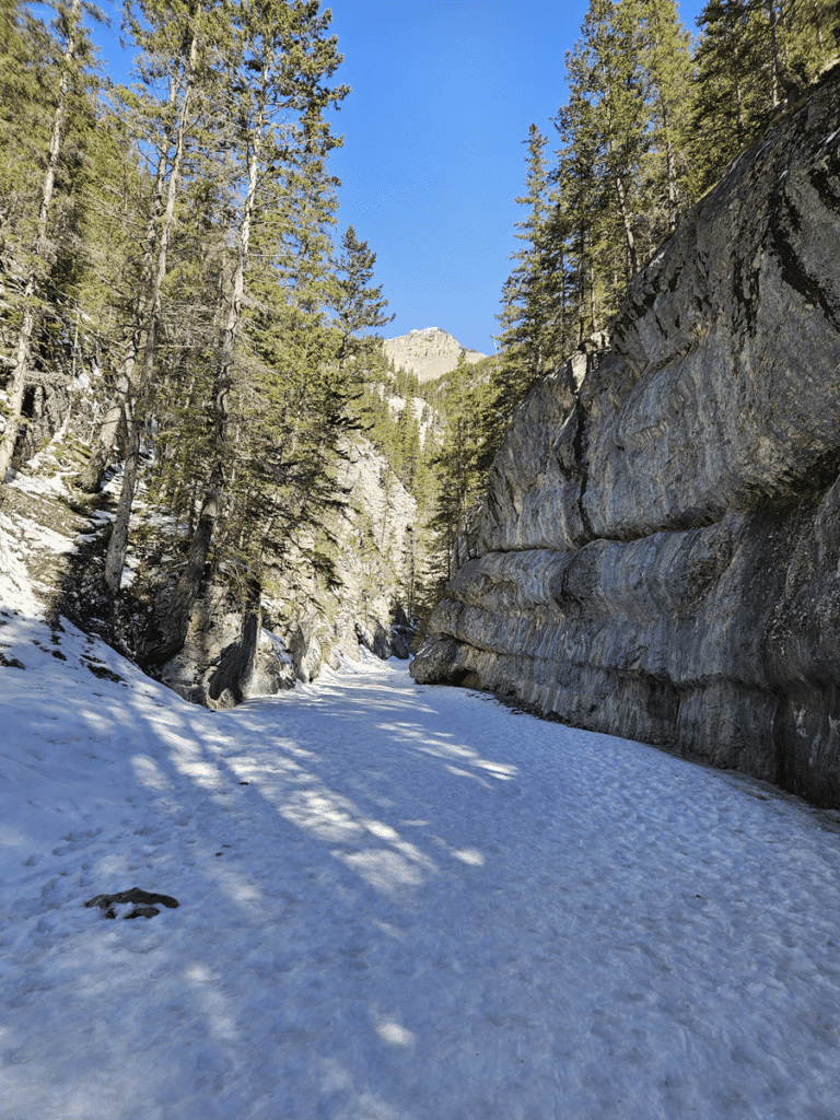
Look to the left at the narrowest part of the canyon to spot ancient pictographs on the rock wall, estimated to be between 500 to 1300 years old. It’s crucial not to touch these drawings to preserve them.

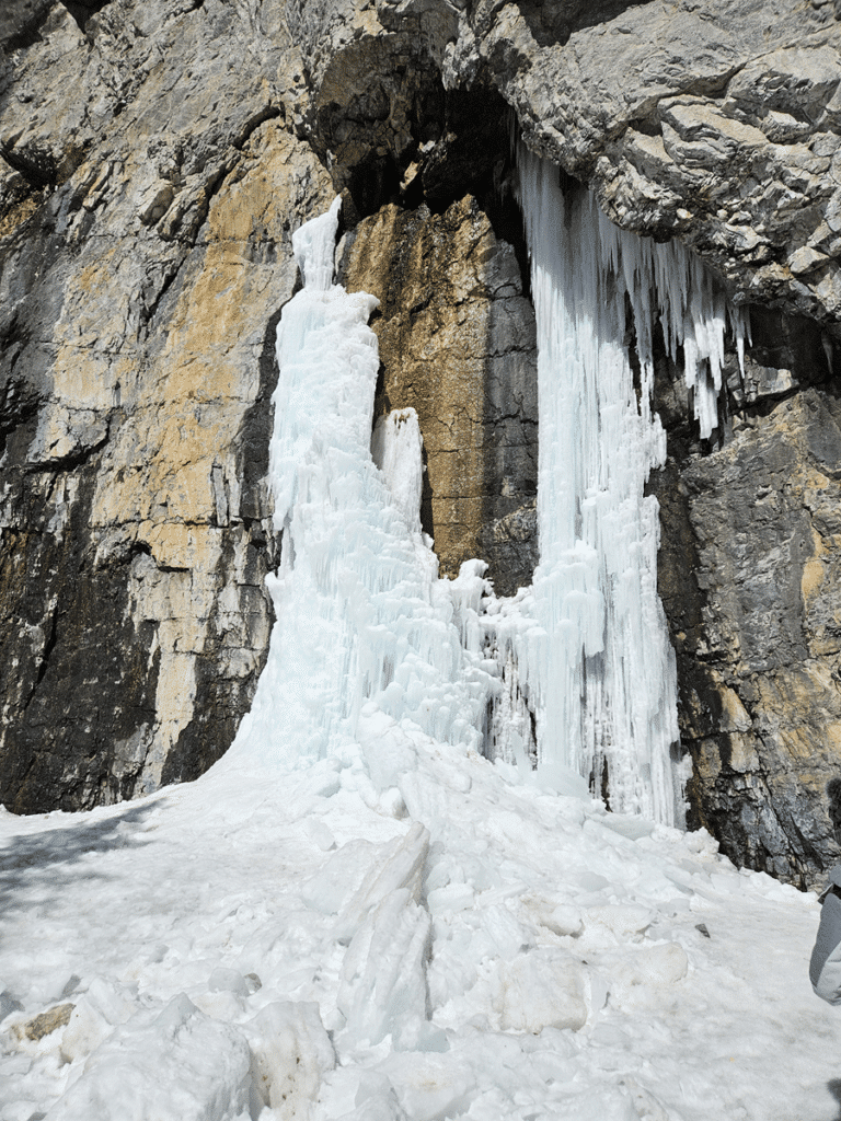
Right after the pictographs you will reach the amazing ice falls. Enjoy the scenery and if you are lucky you will catch some rock climbers traversing the walls. At this point many people will turn and head back on the same trail. If you want to continue exploring, then read the next section.
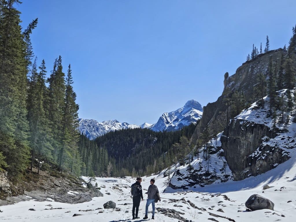
After the impressive falls, if you take the trail to the left, you can venture into the riverbed. Follow the trail over the rocks and you will have amazing scenery and come upon a cave. It is quite steep to climb up to it, so admire from a distance. If you keep traveling further, you can continue along the creek bed to another climbing wall and cave past that. From the ice cave to the climbing wall and back is approximately an additional 3 kms.
Bow River Loop Trail
Distance: 2.1 kms (1.3 miles) | Difficulty: Easy | Dog Friendly: Yes, on leash |
| Loop | Elevation: 54 metres (177 feet) | Washrooms: In Town |
This leisurely loop, starting on the edge of town, offers a very easy Canmore hike along the river, with opportunities to spot local wildlife like elk and birds.
While on this loop, you will cross the Canmore Engine Bridge. If you watched the Netflix series, “The Last of Us”, this is the bridge that they crossed in the show. The mountains provide a stunning backdrop for this leisurely stroll along the Bow River.

Policeman’s Creek Boardwalk Trail
Distance: 4.0 kms (2.5 miles) | Difficulty: Easy | Dog Friendly: Yes, on leash |
| Out & Back | Elevation: 72 metres (236 feet) | Washrooms: In Town |
This is another easy Canmore hike. Some may say it’s even just a walk. Starting from downtown Canmore, this very easy trail follows Policemen’s Creek, weaving through forests and beside serene ponds. It links with over 70 kilometers of interconnected walking trails, allowing for extended exploration if you are feeling adventurous!
The trail is level and mostly paved with a few stairs in some areas. It can get very busy but the payoff comes in the form of the views of the Three Sisters and Mount Rundle. It is also great for birdwatching. One year we were on the boardwalk to find a rare bird that was visiting from Eastern Canada.

Bow River Trail
Distance: 6.0 kms (3.7 miles) | Difficulty: Easy | Dog Friendly: Yes, on leash |
| Out & Back | Elevation: 129 metres (423 feet) | Washrooms: In Town |
This path goes beside the Bow River in Canmore. You can start walking from the Rundle parking lot near the Bow River Bridge or anywhere along the path. It’s a mix of smooth and bumpy paths, mostly flat. It may get icy in the winter or after raining, so ensure you have proper footwear. Along the way, you’ll see beautiful views of the Bow River and the mountains. The parking lot near the start of the path is quite small, so it’s better to come early to avoid the crowds.
Quarry Lake Loop Trail
Distance: 1.3 kms (0.8 miles) | Difficulty: Easy | Dog Friendly: No; But Yes in the Park |
| Loop | Elevation: 43 metres (141 feet) | Washrooms: Yes |
The park is located just past the Canmore Nordic Centre and this recreational area has easy walking paths. It’s also a great spot for picnics, paddleboarding and swimming in the summer.
The trails are mostly gravel or dirt but are easy to follow. The park is very popular so be prepared! The last time we visited, we couldn’t get a parking spot. So we left and came back a few hours later and we were able to get in.
Dogs are not allowed on the trail around the lake, however right in front of the parking lot is an off leash park – so your pup can get in a good run. If you follow the trail straight through the trees, you can explore on the other side. Technically you can go off and explore that area as well, without a dog.
Note: You must pay for parking in this lot, which is separate from the fee paid for the Kananaskis Conservation pass.

Heart Creek Trail
Distance: 4.8 kms (3.0 miles) | Difficulty: Moderate | Dog Friendly: Yes on leash |
| Out & Back | Elevation: 300 metres (984 feet) | Washrooms: Yes |
The Heart Creek Trail is a beginner-friendly hike suitable for all ages, starting near a parking lot off the highway. The trail winds through a mini canyon, with easy-to-follow paths and man-made bridges over the creek. The end has a small waterfall that is a nice finish to the trail. The trail is accessible year round, but ensure you are wearing proper footwear depending on the conditions.

Heart Creek Bunker Trail – Add On
| Distance: 4.0 kms (2.5 miles) | Difficulty: Moderate | Dog Friendly: Yes on leash |
| Out & Back | Elevation: 235 metres (771 feet) | Washrooms: Yes |
Once you finish the Heart Creek Trail, if you head the opposite way, you can explore the Bunker. This hike runs next to the Trans Canada Highway and leads to an abandoned cold war-era bunker. Finding the trailhead is sometimes confusing, but given the amount of people doing the hike, just follow the crowds.
The unlit bunker can get dark and crowded, so bringing a headlamp is highly recommended for safety and convenience.

Where Else Can You Hike Near Canmore?
If you are coming from Calgary, there are many trails that are 30-45 minutes from the city. If you want to hike close to Calgary and not drive all the way to the mountains, you can do so and still get the same beauty of the outdoors. There are also hikes in southern Kananaskis that are an hour or so away from Calgary.
If you are willing to travel an hour from Canmore, there are fantastic hikes in Kananaskis Country off Highway 40, in Peter Lougheed Provincial Park, which is a different area than mentioned above. Banff National Park is just past Canmore and in 20 minutes you can do some great hikes near Banff. If you have the time, then you can venture deep into the Canadian Rockies for some easy hikes in Jasper National Park.

Hiking Safety Tips
Final Thoughts
Exploring easy hikes near Canmore is a rewarding experience to complement your visit to the Canadian Rockies. Whether you’re a seasoned hiker or just starting out, these trails provide an opportunity to appreciate nature’s beauty in one of Canada’s most picturesque areas.
If you enjoyed my post, follow me on social media or subscribe to my newsletter below, so you can stay connected on future posts, trips, tips and more.